Rapid population growth and accelerated consumption create ever greater needs for food, energy, and maritime trade. Due to space limitations on land, coastal areas and marine areas are increasingly being sought after for the establishment of economic activities, taking advantage of new technological and scientific developments.
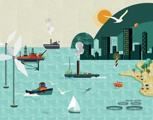
Since marine resources, as well as maritime space, are limited, the economic development of certain activities has had negative consequences for marine biodiversity and, consequently, for the good environmental status of the marine environment. The pressures generated by the disordered development of some economic activities on the marine environment can give rise to two major types of conflicts: i) damage to ecosystems and ii) installation of activities incompatible with each other and with administrative restrictions.
 |
The ordering of activities that take place at sea is now a world priority and several countries are concerned with the organization of maritime spaces under their jurisdiction.
In Portugal, the concern with the defense of maritime areas with a view to the common good is old. On December 31, 1864, in the reign of D. Luís, the margins of maritime, fluvial and lake waters navigable or floating, were integrated into the public domain of the State. This can be considered as the first step towards ordering, or at least, to discipline the use of activities that occurred in maritime areas under Portuguese jurisdiction.
The Portuguese sea planning was formally assumed by the Assembly of the Republic in 2014, through the Basic Law of the National Maritime Spatial Planning and Management Policy. This diploma aims to manage the human activities that occur in the Portuguese sea, both in spatial and temporal terms, with a view to minimizing conflicts, compatibility between activities and uses and the sustainable use of marine resources and services. . It should cover the complete cycle of identifying problems and opportunities, gathering information, planning, making decisions, executing, reviewing or updating.
According to the Basic Law for the Ordering and Management of the National Maritime Space, the Ordering of the National Maritime Space will be done through the preparation of the Situation Plan. Thus, the Situation Plan will be an instrument of economic, social and environmental development, spatial management, legal consolidation and geopolitical affirmation of Portugal in the Atlantic basin and is being prepared jointly by DGRM, by the Central Government, by DROTA (Regional Directorate for Territorial Planning and Environment - Regional Government of Madeira) and DRAM (Regional Directorate for Sea Affairs - Regional Government of the Azores).
According to the Basic Law for the Ordering and Management of the National Maritime Space, the Ordering of the National Maritime Space will be done through the preparation of the Situation Plan. Thus, the Situation Plan will be an instrument of economic, social and environmental development, spatial management, legal consolidation and geopolitical affirmation of Portugal in the Atlantic basin and is being prepared jointly by DGRM, by the Central Government, by DROTA (Regional Directorate for Territorial Planning and Environment - Regional Government of Madeira) and DRAM (Regional Directorate for Sea Affairs - Regional Government of the Azores).